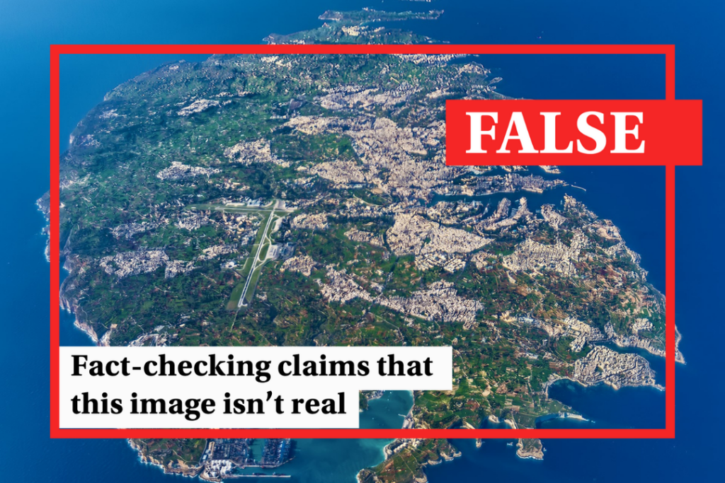
A widely shared aerial photograph of a lush, green Malta raised eyebrows in early April, with some suggesting that the photograph is an AI-generated image.
The photo was first posted over a year ago by Heritage Malta but went viral again in recent days when it was reshared by several Facebook groups, often without crediting the photographer.
The beautiful image quickly raked up thousands of likes, comments and shares.
Amidst the many admiring comments, several others expressed their disbelief, saying that there’s no way the picture could be genuine, given Malta’s rampant overdevelopment and arid climate.
Some commenters went as far as to confidently say that the image is AI-generated, while others speculated on when the photo was taken, saying it can’t have been recent.


When was the photo taken?
The stunning photo is the work of local photographer Daniel Cilia, the same photographer who captured an equally beguiling shot of Mount Etna spewing rings of smoke just days ago.
Contacted by Times of Malta, Cilia said that the aerial photo of Malta was taken over a decade ago, back in early February 2013.
Cilia explained that at the time he had agreed with Maltese aviation company Malta Wings to commission a Cessna 206 plane to snap a series of pictures of the entire Maltese archipelago at 10,000 feet.
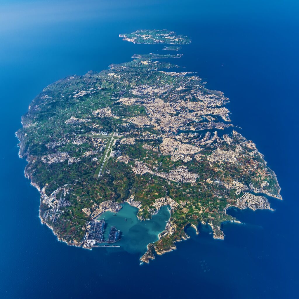
At that height, Cilia had to brave the sub-zero temperatures to open the plane’s window and capture the images.
“I was actually getting frostbite in my hands, a problem which I did not foresee,” he said.
Cilia ended up taking almost 600 photos on that flight, some of them from a similar height to that of the photo which has been shared in recent days, but many others from a different perspective as the plane was ascending.
“To get to the maximum height we had to rotate around Malta twice so as we were rising, I had the opportunity to photograph details from that height with a telephoto lens which is not usual for aerial photographs,” Cilia said.
Some of the photos taken during the same photoshoot made their way into several publications, including the front cover of a book about Valletta and a 2019 issue of an Italian archaeological magazine produced in collaboration with the Malta Tourism Authority.


Was the photo manipulated?
No more than any other professional documentary photograph typically is.
Cilia explained how the photographs were taken in RAW format, a format used by all professional photographers which prevents a camera’s computer from manipulating the image.
The image is then edited by the photographer to bring out the contrast and colour.
“I could have made the colours brighter and more saturated, but I wanted to present them as close as possible to how we saw the archipelago from up there,” Cilia said.
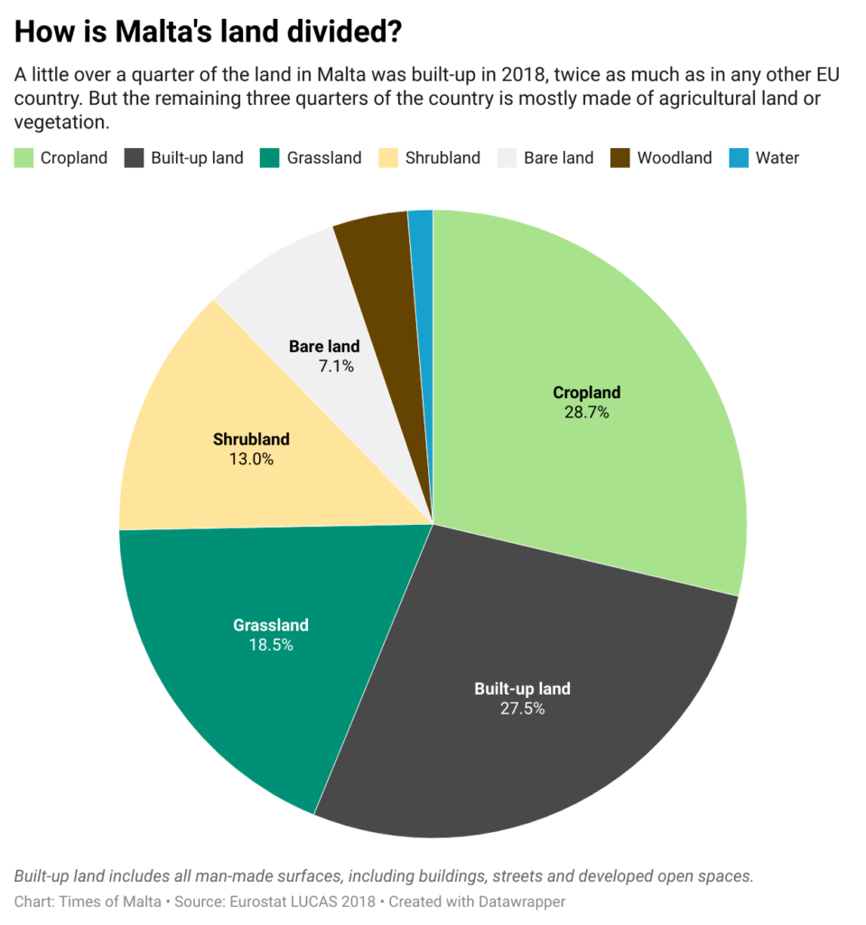
Is Malta really that green?
Certainly not during the drier months, but weather records show that Malta had experienced some 123mm of rainfall over the two months before the photo was taken. While this was lower than the seasonal average, it still goes some way to bringing Malta’s resilient vegetation back to life.
Meanwhile, despite Malta’s increasingly rampant development, most of the land across the Maltese islands was still made of open spaces such as agricultural land, or wild vegetation.
EU data shows that, in 2012, months before the photo was taken, just under quarter of Malta’s land was built-up or covered with man-made surfaces, at 23.8%
This remained virtually unchanged in 2015, when Malta’s land was once again surveyed, but shot up to 27.5% in 2018, as urban sprawl intensified. More recent data on Malta’s land use is still being compiled.
Malta’s ratio of built-up land is by far the highest in Europe, more than twice that of second-placed the Netherlands at 12.6%. The EU-wide average is a measly 4.5%.
However, this still means that almost three-quarters of Malta’s land is taken up by arable land, garrigue vegetation and green spaces.
In fact, in 2018, cropland made up the highest percentage of Malta’s land, at 28.7%. Grassland was almost a fifth of the total land area, while shrubs made up a further tenth of Malta’s land.
This is not the first time that aerial images of Malta raised suspicion. Last year, a satellite image claiming to show a bone-dry Malta in November 2022 turned out to have been taken a year earlier.
Verdict
The image being shared is a photo taken by photographer Daniel Cilia in February 2013.
Cilia took almost 600 photos during that same shoot, some of them eventually making their way into published books and magazines.
The edits made to the photo were typical of any professional photograph and the image was not drastically enhanced.
Despite Malta having a higher proportion of built-up area than any other EU country, the majority of the island is still made up of open spaces such as agricultural land or wild vegetation.
This claim is therefore false, as the evidence clearly refutes the claim.
The Times of Malta fact-checking service forms part of the Mediterranean Digital Media Observatory (MedDMO) and the European Digital Media Observatory (EDMO), an independent observatory with hubs across all 27 EU member states that is funded by the EU’s Digital Europe programme. Fact-checks are based on our code of principles.
Let us know what you would like us to fact-check, understand our ratings system or see our answers to Frequently Asked Questions about the service.
The image is a real photo taken in February 2013. Photo: Daniel Cilia
Environment, Fact Check, Technology
Copyright 2024 Times of Malta. All rights reserved.
Originally published here.