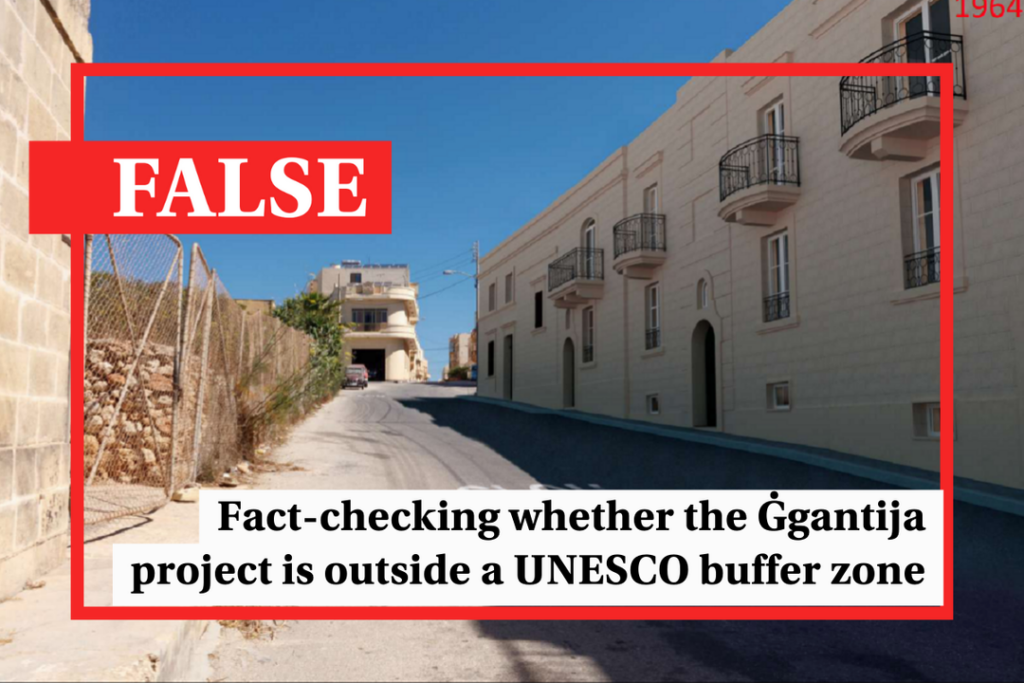
A controversial planning application to build a 22-apartment block just 157 metres away from the site of Ġgantija temples was approved on November 9, despite a UNESCO request for a heritage impact assessment to take place.
Ġgantija temples, believed to be one of the oldest free-standing structures in the world, are located on the island of Gozo. They are a UNESCO World Heritage site, meaning that any development in the immediate vicinity is subject to UNESCO’s rules.
The decision on the application had previously been suspended to give time for an impact assessment to be carried out.
However, when the hearing resumed on Thursday, the project’s applicants successfully argued that the development lies outside the buffer zone established by UNESCO to protect heritage sites, meaning that there was no need for a heritage impact assessment.
Instead, the applicants argued, the development is simply in an area of archaeological importance, which extends beyond the buffer zone.
The PA board agreed and approved the proposal.
The decision infuriated many objectors, who insisted that the development actually does lie within the buffer zone.
What is the UNESCO buffer zone?
UNESCO protects world heritage sites by creating a zone surrounding each site in which development is restricted. This is known as the buffer zone.
In practice, this is a zone that shields the heritage site from the rest of the city, town or village.
While this doesn’t mean that development in the buffer zone is forbidden, UNESCO places legal restrictions on any kind of development, insisting that the impact must first be assessed and approved by its World Heritage Committee.
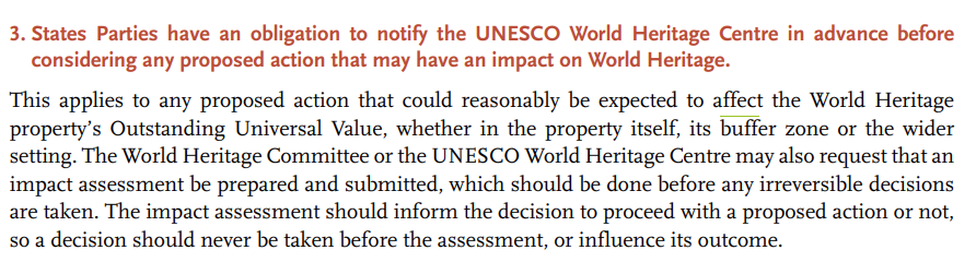
The buffer zone isn’t intended to just protect the site itself, but also “important views and other areas or attributes” that may have some kind of visual impact on the site.
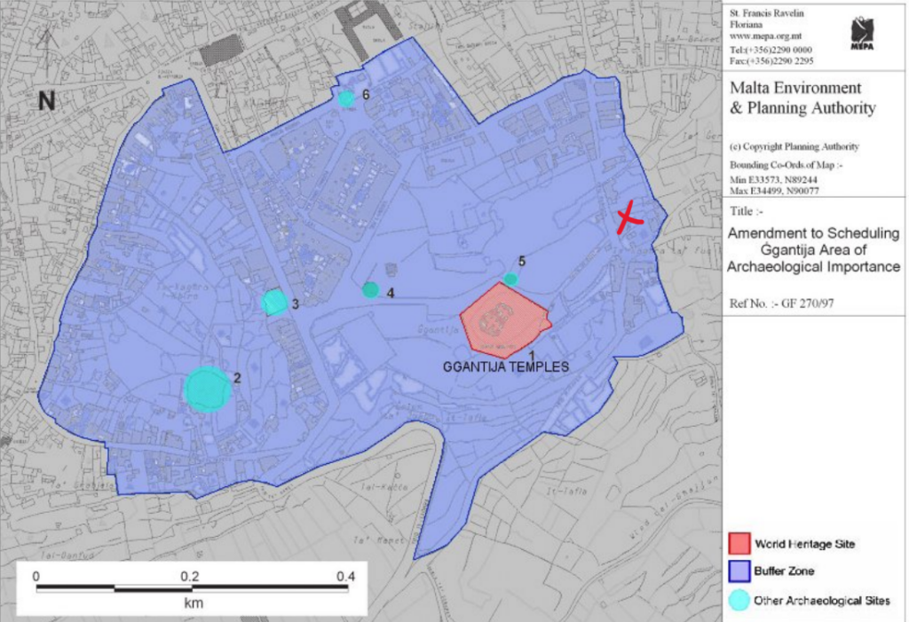
What is Ġgantija’s buffer zone?
This has changed over the years.
Malta’s first go at creating a buffer zone for the site, in the early 1990s, didn’t go down too well with UNESCO. Notes from a committee meeting held in Paris in the summer of 1992 show UNESCO telling the Maltese government of the “necessity of establishing a larger buffer zone with better legal protection”.
The government quickly followed these instructions, according to a similar note published later the same year.
Maps on UNESCO’s website show that this resulted in the government extending the buffer zone to stretch across parts of Xagħra.
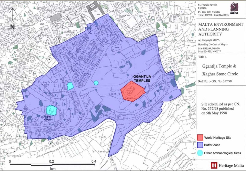
Things remained in place until March 2015 according to UNESCO’s documentation, when a report by the International Council on Monuments and Sites (ICOMOS) recommended that the buffer zones for many world heritage sites across the world, including Ġgantija and other sites in Malta, be extended further.
In Ġgantija’s case, this meant adding a sliver of land on the Eastern edge of the buffer zone, just off Triq Parsott, as well as a larger chunk of land on its Western side.
This modified buffer zone was officially approved by UNESCO in the summer of 2015.
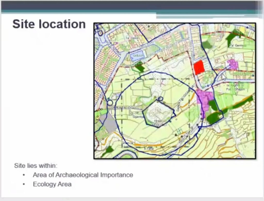
What is an area of archaeological importance?
This is where things get slightly confusing.
This is a designation created by Maltese authorities to highlight areas that have a high degree of archaeological value. However, it is not a term specifically used by UNESCO when discussing world heritage sites and their protection.
The Maltese government listed Ġgantija and its surrounding area as an area of archaeological importance through a notice in Malta’s Government Gazette in August 2010, also publishing a map of the area being protected for good measure.
The map setting out this area of archaeological importance is identical to the most recent buffer zone adopted by UNESCO, down to the slightest contour.
This means that, in practice, the area of archaeological importance and the buffer zone are one and the same thing, at least in Ġgantija’s case.
What happened during the PA sitting?
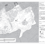
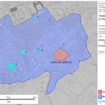
When making the case for the proposal’s approval, the project applicants presented a crudely drawn map showing three separate demarcation lines on the site.
One is the perimeter of Ġgantija temples themselves, the second is a circular ring supposedly showing the buffer zone, and the third is an outer boundary which, the architect said, shows the area of archaeological importance.
This map, the applicants said, shows that the development is inside the area of archaeological importance, but just outside the buffer zone.
However, the buffer zone marked on the architect’s map is wildly different, and far smaller, than that approved by UNESCO in 2015.
It is not clear how the buffer zone marked on the architect’s map was drawn up, however informed sources told Times of Malta that it is similar to the site’s very first buffer zone which earned Malta a rebuke from UNESCO back in the early 1990s.
Attempts to contact Samuel Formosa, the project’s architect, were unsuccessful at the time of publication.
So, is the development within the buffer zone or not?
Yes, it is.
While this was not the case in earlier versions of the buffer zone, the 2015 modification meant that the proposed development site is now nestled just inside the zone.
In fact, the development is right on Triq Parsott, the small strip of land on the buffer zone’s Eastern side that was added in 2015.
This means that, according to UNESCO’s rules, development cannot take place on the site unless a heritage impact assessment has been carried out and approved by its World Heritage Committee
Can’t Maltese authorities simply ignore UNESCO’s instructions?
Things are a little more complicated than that.
UNESCO’s conventions are not simply guidance documents that can be selectively adopted. They are legally binding treaties that oblige countries to “accept obligations under international law”. This is because world heritage sites are considered to have outstanding value to humanity that stretches far beyond the country in which they happen to be situated.
Malta has signed and ratified several UNESCO conventions over the years, including on the protection of world cultural and natural heritage way back in 1978.
The documentation filed for this particular development suggests that authorities were well aware of the obligations imposed by UNESCO.
Throughout 2022, the Superintendence of Cultural Heritage claimed that the project had been reviewed and accepted by UNESCO’s technical committee, even saying so in two letters to the Planning Authority in February and August 2022.
However, UNESCO appears to have had other ideas. In two letters sent in late 2022 and seen by Times of Malta, the director of UNESCO’s World Heritage Centre raised his concerns over the proposal with Malta’s Permanent Delegate to UNESCO, Ambassador Mons. Joe Vella Gauci.
“I would like to reiterate that, again in accordance with the Operational Guidelines, an HIA (heritage impact assessment) should be carried out as a pre-requisite for development projects and activities that are planned for implementation within or around a World Heritage property”, he wrote.
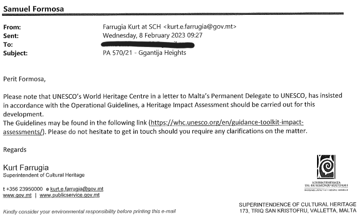
Following these letters, the Superintendence changed tack entirely, with the Superintendent of Cultural Heritage, Kurt Farrugia writing to the project architect on 8th February 2023 telling him that the UNESCO’s World Heritage Centre “insisted” that a heritage impact assessment needed to be carried out for this project.
This resulted in a decision on the project being delayed during a sitting held later that same day.
Verdict
While earlier versions of the buffer zone did not include the development’s site, a modified version of the buffer zone approved by UNESCO in 2015 means that the site is now just within the buffer zone.
The area of archaeological importance, established by Maltese authorities, and the buffer zone effectively cover the exact same stretch of land. This means that all sites within this particular area of archaeological importance also fall within the buffer zone.
The buffer zone boundaries presented by the project’s architect do not reflect the most recent buffer zone, as indicated by UNESCO.
UNESCO conventions on the protection of cultural heritage are legal documents governed by international law, and contravening them may constitute a breach of international law.
The Times of Malta fact-checking service forms part of the Mediterranean Digital Media Observatory (MedDMO) and the European Digital Media Observatory (EDMO), an independent observatory with hubs across all 27 EU member states that is funded by the EU’s Digital Europe programme. Fact-checks are based on our code of principles.
Let us know what you would like us to fact-check, understand our ratings system or see our answers to Frequently Asked Questions about the service.
The project’s applicants claimed that the site is just outside the buffer zone. Photo: Planning Authority
Copyright 2023 Times of Malta. All rights reserved.
Originally published here.